How to get there
Address: 156 Turracher Höhe, 9565 Ebene Reichenau, Austria.
Turracher Höhe is a 15 hour drive from the UK so most people would probably opt to fly from the UK and to hire a car.
Flying
The closest airports are Klagenfurt (1 hour) and Salzburg (2 hours).
You can fly to Klagenfurt from London Heathrow with a connection in Vienna with Air Austria (daily flights).
You can fly to Salzburg direct from London Gatwick with either British Airways, Easyjet. British Airways has flights on Mondays, Wednesdays, Fridays, Saturdays and Sundays. Easyjet flights are only on Fridays, Saturdays and Sundays. Flybe have an alternative service from Southampton on Saturdays.
An alternative would be to fly into Venice and have a 3 hour drive to the resort.
Driving
Directions are as follows:-
From the North (Salzburg Airport)
Take the A10 south towards Spittal an der Drau. After 100Km take Exit 104 at St Michael im Lungau and head towards Tamsweg on the B99. At Tamsweg merge south onto the B95 towards Predlitz-Turrach. At Predlitz-Turrach, take the right turn to Turracher Höhe (this is still the B95).
It is a good 25 minute climb up to Turracher Höhe from Predlitz-Turrach!
From the South (Klagenfurt Airport)
Take the A2/E66 towards Villach. After a few minutes you will enter a very long tunnel. Immediately you leave the tunnel take the exit for the B95 towards Feldkirchen. Follow the B95 past Feldkirchen, all the way to Turracher Höhe. The climb to the village is steeper from the south, sometimes a 23% climb so it is essential to be prepared in snowy conditions!
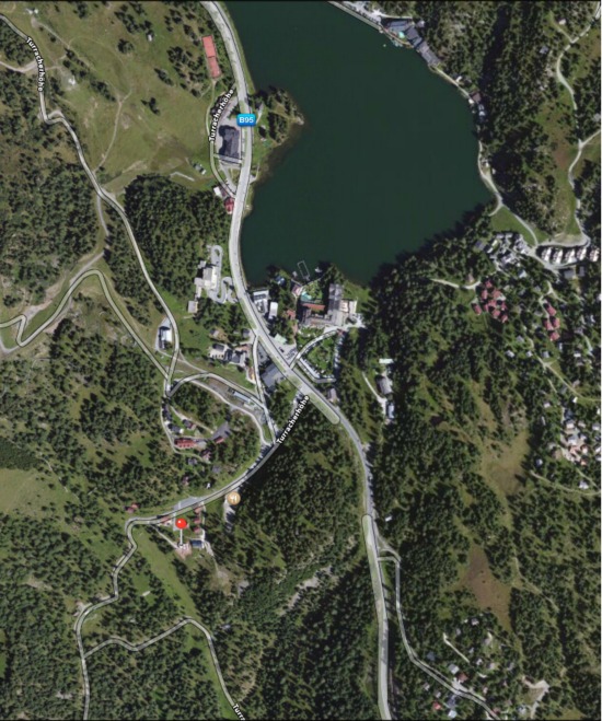
Once in Turracher Höhe
The Chalet is located at the South end of the village. Take the turning to the Panoramabahn/Nocky Flitzer and drive past the lift station. Keep on this road as it goes downhill and you will see a white house on your left. Take the left drive immediately after the white house and this the approach to Jägers Mond.